Getting There…
Getting There…
by admin on Jul.31, 2003, under Directions
The property is about 15 miles west of Seligman, which is about halfway between Flagstaff and Kingman, Arizona.
It is approximately 45 miles SouthEast of the Havasupi Falls of the Grand Canyon.
The nearest town is Seligman, Arizona.
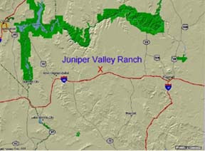
The Juniper Valley Ranch is located about 15 miles west of Seligman, Arizona, about 4 miles north of Interstate 40.

The Ranch is most easily accessed via exit 109 on Interstate 40.

Exit 109 from the westbound lane of I-40 (Anvil Rock Road).

Here is what it looks like at the top of the exit. We turn south (left) here, passing over the interstate.

This is the view as we head south over the interstate. Continue to the Tee in the road, just a little further.

At the tee, we turn back west (right), and parallel the interstate for a couple of miles.
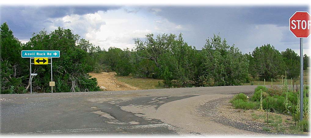
Here is what the county road looks like that parallels the interstate.

After about two miles running parallel to the interstate, you will see a windmill on the left, and an underpass on the right. We want to turn right go under the underpass (heading north).

Just after the underpass, you will encounter a gate. Go through it, and please close it behind you, so the cows don’t get out.

Continue north on the ranch road about 4 miles. You will come on an intersection, and will be able to see a large windmill just to the right. Turn right here.

Immediately after you turn right, you will see the second cattle gate. Go through this gate and continue east until the road turns north (half-mile ,maybe?)

After the road turns north, you will see the same windmill on your left. Continue past it.

About a half-mile after passing the windmill, you will see our green fencepost with white tops marking the west property corners of the Juniper Valley Ranch. You have arrived! The lane is to the right.


July 13th, 2009 on 5:24 am
Randy, What happened to the second Gate? Do not remember that one.
John
July 13th, 2009 on 5:42 am
Hi John.
The second gate was up for many years, but never used. The rumor on the BBS is that someone stole it a couple of months ago. It was at the sharp right turn before the Well #5 site.
April 23rd, 2011 on 8:21 pm
Randy,
You are close. The picture of the county road with the sign pointing to the left for Anvil Rock Road, we turn left and go down Anvil Rock about 5 or 6 miles, then left for a couple miles.
April 24th, 2011 on 10:18 am
Hi Bo. Yes, we know that area. That is close to where they used to hold the annual Property Owners picnic/annual meeting.
BTW, there are two other sites you may be interested in. One is the “official” Property Owner’s site: http://www.cidmgmt.com/svr
which is where you can pay your annual POA dues, and look up board meeting info, etc.
The other is http://www.sierraverderanch.org which is a private site run by one of the owners. It has a Bulletin Board and a fairly active group of neighbors on it.
Like all bulletin boards, it can get contentious at times, but overall is worth reading the posts.