Posts

Showing posts from May, 2003

More of the Ranch in May

Image
  More of the Ranch in May by admin on May.30, 2003, under Seasons The Meadow May 24th, 2003. Early Evening. A view to the west from the East end of the Ranch. The meadow is fairly healthy at this time of year.   Meadow Northeast Corner May 24th, 2003. Late Afternoon. Looking across the meadow to the hill on the north side of the property. We don’t know what the bright orange wildflowers are yet.

May Life at the Ranch…

Image
  May Life at the Ranch… by admin on May.30, 2003, under Seasons May Cool nights and warm days What a great time of year to be visiting Juniper Valley Ranch. Flowers and cactus are in bloom, grass is green, sunsets are out of this world beautiful. The temperature drops immediately after sunset to make for a very pleasant evening. Gunner’s Mate Road May 24th, 2003. Late Afternoon/Early Evening. Here is the recently named “Gunner’s Mate Road”, which borders the Ranch’s northeast corner.   Gunners Mate Road East Property Line May 24thth, 2003. Afternoon. The east side of the Ranch faces Black Mountain and it’s associated foothills.   Property Line East Looking East May 24th, 2003. Late Morning/Early Afternoon. A view from the western edge of the Ranch, looking East. The lower end (here) of the property is kind of scrubby, with more trees and grass on the far (upper) end.   Looking East from Western Edge South View May 24th, 2003. Late Afternoon. Looking ac

Property Details

Image
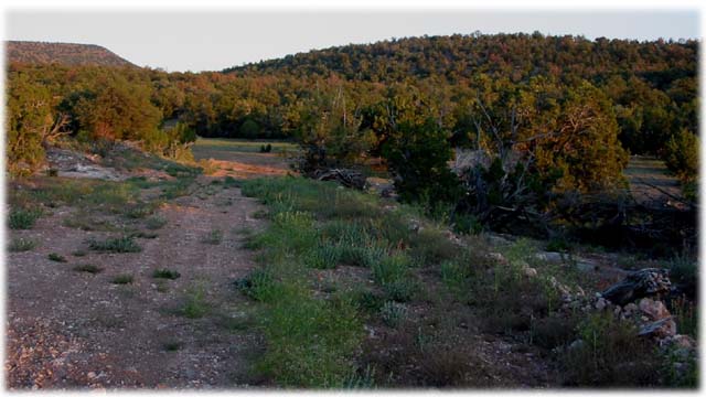
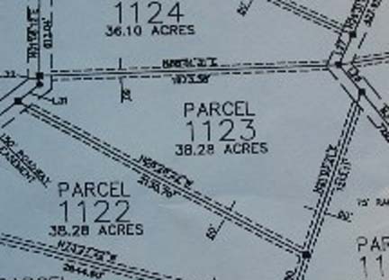
  Property Details by admin on May.29, 2003, under Land Details Juniper Valley Ranch is a 38 acre wedge shaped parcel, approximately 2000 feet on the north and south sides, 1500 feet on the east side, and 300 feet on the west side. It is part of the Sierra Verde Ranch development. There are mountains surrounding us on three sides, isolating us from most of the rest of the world.     Lot Plan It is located in Unit 26 of the Sierra Verde Ranch development. Section 33, T23N, R8W, G.&S.R.M. Yavapai County, Arizona. The relief map below shows the nature of the terrain around the ranch. You can see that the west opens up to a large basin, and there are mountains on the other three sides.   Overhead View Here is a closer view of the relief map.   Close Up Here is an aerial photo overlaid with topographic lines, as well as the Ranch outline and existing road.   Plot Topo The overhead photo of the ranch shows the Juniper and Pinyon tree cover on the north and south